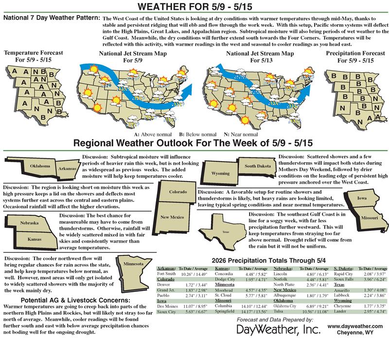
Texas and Deep South beneficiaries of recent rains
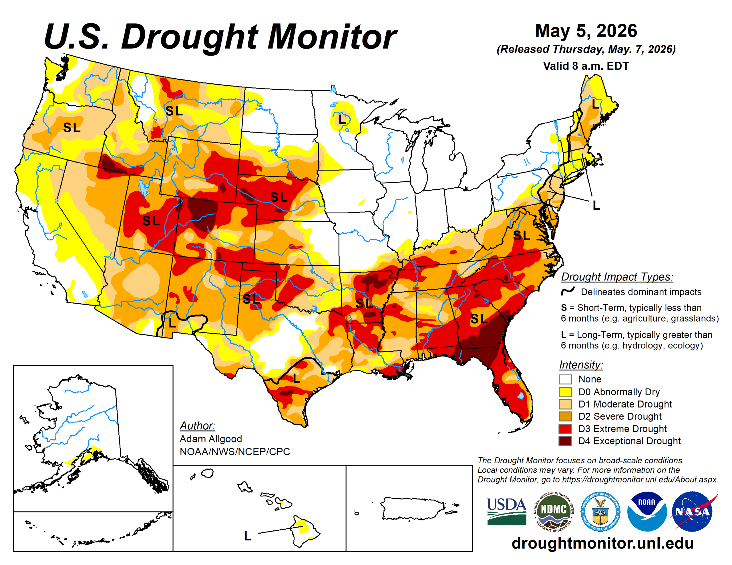
Widespread soaking rains fell across Texas and the Deep South, bringing a much-needed moisture boost to these drought-stricken areas.
While sufficient to ease drought conditions across portions of Texas, the lower Mississippi Valley, and the Tennessee Valley, drought conditions remained mostly unchanged across southeastern Alabama, Georgia and northwestern Florida, where soil moisture and streamflows remain extremely low. Lighter rainfall also overspread the Northeast, which, combined with cooler temperatures helped slow the advancement of drought, and improved drought conditions in Maine.
Where lighter accumulations occurred, there was slight expansion of drought and abnormal dryness across portions of the mid-Atlantic, Hudson Valley, and southeastern New England. Cooler temperatures and mostly dry weather overspread the Plains and Midwest. While drought conditions continued to expand across the Plains, the drier weather was mostly welcome across the upper Midwest and Corn Belt, allowing fieldwork to progress.
Hot, dry weather promoted degradation across Arizona and northwestern Washington, while late season moisture across northern California did little to change the meager snowpack conditions.
The U.S. Drought Monitor is jointly produced by the National Drought Mitigation Center at the University of Nebraska-Lincoln, the U.S. Department of Agriculture and the National Oceanic Atmospheric Administration. (Map courtesy of NDMC.)
South
Following last week’s beneficial rainfall, additional rain overspread much of Texas and Louisiana over the last several days, sparking additional drought reductions. Rainfall across central and western Texas eased drought across the upper Rio Grande Valley as well.
Despite the beneficial rainfall, widespread severe to exceptional drought continues across the South Region, and it will take a sustained series of heavy precipitation events to begin any widespread easing of impacts. The beneficial rainfall missed the Texas Panhandle and western Oklahoma, where poor conditions continue to affect rangeland and winter wheat. Drought conditions also expanded across Arkansas.
Midwest
Following a period of sustained wetness across the region, drier conditions overspread the Midwest over the past seven days. Unseasonable cold reduced evapotranspiration rates, and the pause in precipitation was mostly welcome for fieldwork activities that were delayed by the frequent storm systems. Impacts from drought and abnormal dryness eased across northern Minnesota and along the southern Indiana and Illinois border. Slight degradations were noted across southeastern Missouri and right along the Ohio River in south-central Indiana, as these regions missed out on some of the prior precipitation.
High Plains
Light to moderate precipitation overspread much of the High Plains, with the heaviest accumulations (0.5 to 1.5 inches) falling across central Colorado, including late season snow across the higher elevations. This precipitation resulted in some drought reduction across central Colorado. Across the rest of the Plains, however, the moisture was not sufficient to engender substantive improvements. Despite cooler temperatures lowering evapotranspiration rates, some degradation occurred across Kansas and Nebraska, and far western North Dakota.
West
Outside of northern California, where late season moisture provided a boost to short-term streamflows and soil moisture but did little to change the unusually low snow cover across the northern Sierras, seasonably dry weather overspread most of the West.
Recent moisture eased drought conditions across far western Montana. While little change to the drought depiction occurred across the West, hot, dry conditions exacerbated impacts across Arizona, resulting in some substantial degradation. Short term dryness also increased across northwestern Washington, resulting in expansion of D0.
Looking ahead
During the next seven days, an active pattern is favored to continue across the Southeast, with heavy rainfall (2 to 7 inches) possible along a swath from eastern Texas through southern Alabama.
These rains would continue to bring drought relief and also a threat of severe weather. Lesser accumulations are favored across Georgia and Florida, which may limit the extent of any improvements. Widespread precipitation is also favored along the Ohio Valley and across the eastern seaboard, with the greatest potential for relief across the Northeast. Somewhat drier conditions across the mid-Atlantic may limit the potential for drought improvement.
Light accumulations forecast across the Plains may do little to ease drought conditions, while another week of seasonable dryness is forecast across the West. Above-average temperatures across the West favor an acceleration of snowmelt, which may bring short term reservoir boosts but leaves the water supply even more short as summer approaches. Below-average temperatures are favored for the eastern half of the continental U.S.
During the eight- to-14 day period, above-average temperatures are favored for much of the lower-48, with near normal temperatures forecast for the Northeast. Above-average precipitation is forecast for the southern tier, with the highest probabilities across Texas, eastern New Mexico, and Louisiana. A slight tilt towards above-normal precipitation extends across the Great Lakes Region into the Northeast, while below-average precipitation is favored for the northern Rockies.
Adam Allgood is NOAA/NWS/NCEP/CPC