Scattered heavy rains story of the past week
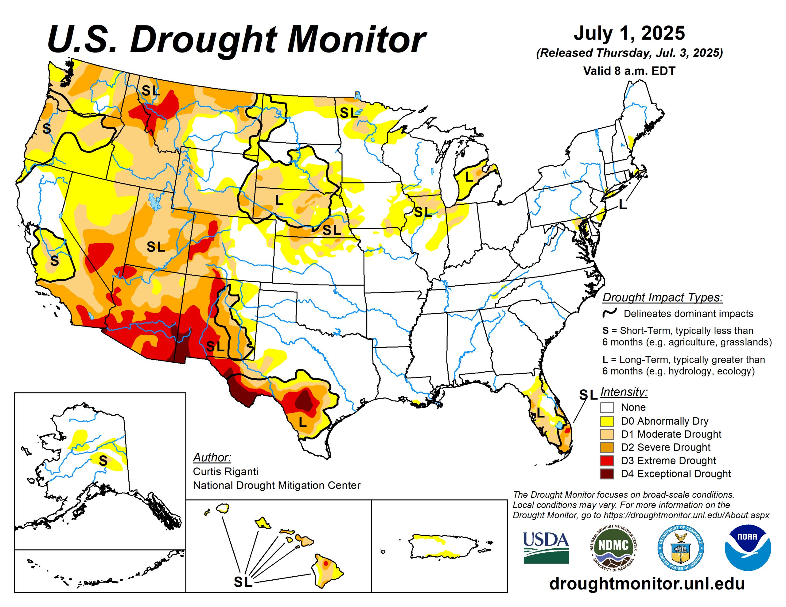
Scattered heavy rains fell over parts of the central Great Plains and Upper Midwest this past week.
Rain amounts were especially heavy in parts of Nebraska and Minnesota, where locally 8 or more inches of rain fell. These rains helped to alleviate drought and abnormal dryness in some areas. A few areas of the Dakotas, Minnesota, Indiana, and Illinois that missed heavier rains saw localized degradations.
Heavy monsoonal rain and thunderstorms also occurred in parts of west Texas and New Mexico, leading to some improvements to ongoing drought and abnormal dryness there. Meanwhile, most areas west of the Continental Divide remained dry or mostly dry. This continued dry weather led to further degradation in drought and abnormal dryness, especially in the Northwest, where severe and extreme drought developed or expanded in coverage.
Conditions in the central Gulf Coast were mostly quiet. Southeast New Mexico and west Texas finished the week 2 to 8 degrees Fahrenheit cooler than normal, owing to rain and clouds from the North American monsoon.
The U.S. Drought Monitor is jointly produced by the National Drought Mitigation Center at the University of Nebraska-Lincoln, the U.S. Department of Agriculture and the National Oceanic Atmospheric Administration. (Map courtesy of NDMC.)
South
Heavy monsoonal rains fell across portions of west Texas, with local amounts of 2 to 3 inches or more. Heavy rains of 2 to 3 inches or more also fell across parts of northeast Oklahoma. Elsewhere, rainfall amounts of at least 2 inches were less common, while southern Arkansas, northwest Oklahoma and portions of central Texas saw mostly dry weather.
Elsewhere across the region, temperatures were mostly 2 to 4 degrees warmer than normal in Arkansas. Outside of Texas, the South region remained almost entirely free of drought or abnormal dryness.
In west Texas, heavy rains from the North American monsoon helped to partially alleviate short- and long-term precipitation deficits and improve soil moisture quantity.
Midwest
Heavy rain fell this week across portions of the Midwest, including central and south-central and northern Missouri, portions of Iowa and southern Minnesota. Temperatures 1 to 4 degrees warmer than normal were more common in Iowa and Missouri, while a small area of cooler-than-normal weather occurred in central Minnesota, where temperatures were mostly 1 to 4 degrees below normal.
A mix of improvements and degradations to ongoing areas of drought and abnormal dryness occurred in Minnesota. In these areas, soil moisture and precipitation deficits and surpluses continued to shift after recent heavy rain or lack thereof.
Improvements to ongoing drought or abnormal dryness occurred in northern Missouri and Iowa where heavy recent rainfall lessened precipitation deficits and improved soil moisture.
High Plains
Very heavy rain fell across parts of southwest and central Nebraska, which extended into portions of northern Kansas (north of Interstate 70) and portions of west-central and eastern South Dakota.
Significant flash flooding occurred from rain amounts locally exceeding 8 inches in Grand Island, Nebraska, while very heavy rain, locally in excess of 5 inches, fell in parts of eastern South Dakota, where significant tornadoes also occurred on June 28. Heavier rain amounts fell in parts of south-central and northeast Colorado as well, though most of the heavier totals were in the 1- to 3-inch range.
Primarily dry weather occurred west of the Continental Divide in Colorado and Wyoming. Temperatures across the region were mostly near normal to 2 to 4 degrees above normal, though parts of the eastern Dakotas were a few degrees cooler than normal. In areas that received heavy rain, soil moisture and precipitation deficits were alleviated and widespread improvements to ongoing drought or abnormal dryness occurred, including a two-category improvement in central Nebraska where some of the week’s heaviest rains fell.
Meanwhile, degradations occurred in northwest Colorado and western Wyoming, where soil moisture and streamflow deficits mounted amid growing precipitation deficits.
West
Heavy monsoonal rains fell this week in parts of New Mexico, excluding the far northwest. Elsewhere, this week’s weather was almost entirely dry. Combined with warmer-than-normal temperatures (mostly by 2 to 6 degrees) in the Northwest states, this led to widespread degradation in drought and abnormal dryness for central and northern Utah, Idaho, parts of northern and much of western Montana, and Washington.
Very low streamflows and large short-term precipitation deficits contributed to widespread expansion of severe and extreme drought in western Montana and adjacent Idaho. Short-term severe drought also occurred in parts of central and north-central Washington, where deficits in precipitation and streamflow continued to grow. In much of New Mexico, excluding the far west and northwest portions, near- or below-normal temperatures were common this week along with some heavier rainfall amounts exceeding 2 inches (locally exceeding 5 inches).
The improved soil moisture and lessened precipitation deficits led to widespread improvements to ongoing drought and abnormal dryness in southeast, southwest and north-central New Mexico. Exceptional drought expanded slightly along part of the Arizona-New Mexico state line where deficits in groundwater and precipitation continued to mount.
Looking ahead
The National Weather Service Weather Prediction Center is forecasting a few areas of rainfall exceeding 1 inch for the period through the evening of July 7. Localized 1-inch or greater totals are possible in locations in New Mexico, northwest Texas, central and eastern Oklahoma, northern Kansas and Nebraska into the Upper Midwest and northern Great Plains, and western Montana.
Mostly dry weather is expected from the Intermountain West to the Pacific Ocean and across much of south Texas.
For July 8 to 12, the National Weather Service Climate Prediction Center forecast strongly favors warmer-than-normal temperatures in the western contiguous U.S., especially west of the Continental Divide. Warmer-than-normal temperatures are also favored in the eastern U.S., especially from Virginia southward to Florida. Near- or below-normal temperatures are favored for parts of the southern and central Great Plains and western portions of the Midwest.
Above-normal precipitation is slightly favored in southern and eastern New Mexico eastward across much of the contiguous U.S.
Curtis Riganti is with the National Drought Mitigation Center.
Related Articles


