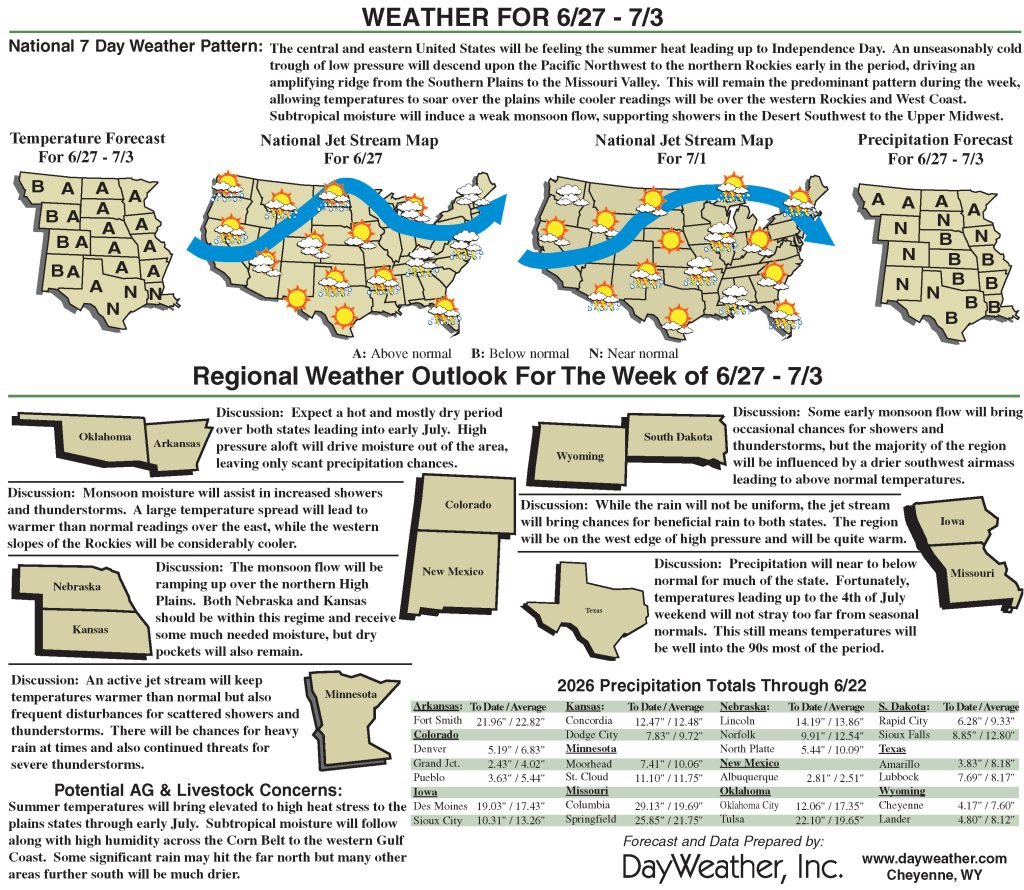
Southern Texas biggest gainer in Arthur event
Storm Arthur briefly formed near the middle Texas coast on June 17, hours before wobbling inland near Galveston.
However, a precursor low-pressure system delivered heavy rain in parts of southern Texas, followed by a post-tropical deluge from the central Gulf Coast region into the lower Southeast. Totals of 4 to 8 inches or more were common across the Deep South, with higher amounts observed in several spots.
Although flash flooding and lowland flooding occurred, overall impacts were muted by antecedent drought, which until recently had spanned the South. Farther north, a series of cold fronts sparked occasional showers and thunderstorms, resulting in localized wind and hail damage but maintaining favorable soil moisture reserves for most Midwestern summer crops.
The Plains also received scattered showers, amid variable impacts related to lingering drought on rangeland, pastures, and summer crops. Meanwhile, the Plains’ winter wheat harvest quickly advanced between showers, as the drought-affected crop dried down ahead of the normal pace.
In the western United States, hot and mostly dry weather prevailed. Complications related to Western heat included heavy irrigation demands and a broadly elevated wildfire threat. One of the region’s most significant wildfires, the Iron Fire near Eureka, Utah, ignited on June 19 and quickly burned more than 37,000 acres of grass and chaparral.
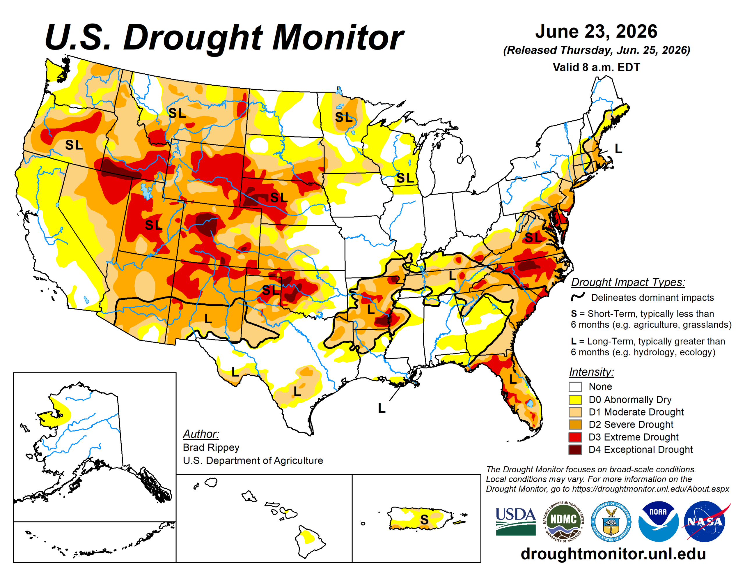
The U.S. Drought Monitor is jointly produced by the National Drought Mitigation Center at the University of Nebraska-Lincoln, the U.S. Department of Agriculture and the National Oceanic Atmospheric Administration. (Map courtesy of NDMC.)
South
Downpours related to frontal interactions with tropical moisture, including Tropical Storm Arthur, delivered drought relief but caused local flooding.
In fact, the western and central Gulf Coast regions became mostly drought-free, following the latest deluge, with broad one-category improvement noted in eastern. By June 21, with periods of heavy rain still falling, statewide topsoil moisture in agricultural regions had increased to 35% surplus in Louisiana, according to the U.S. Department of Agriculture.
The region’s most significant remaining drought existed across parts of Arkansas and environs, along with the northwestern half of Oklahoma.
Midwest
Heavy rain grazed some of the lower Midwest’s remaining drought areas, easing moderate to extreme drought(, especially in Kentucky.
Meanwhile, the upper Midwest was a mixed bag of spotty improvement and deterioration, with intensity ranging from abnormal dryness to severe drought. Between the two areas, rather wet conditions existed. On June 21, according to the USDA, statewide topsoil moisture was rated 43% surplus in Illinois, along with 36% in Missouri, 27% in Indiana, and 26% in Michigan. On that date, USDA reported that roughly two-thirds of the U.S. corn (68%) and soybeans (66%) were rated in good to excellent condition, reflecting mostly favorable Midwestern growing conditions.
High Plains
The region’s eastern states reported drought improvement or unchanged conditions, with a few exceptions.
Streaks of heavy rain led to one-category improvement in a swath across central Nebraska and western and central Kansas. However, the rain arrived too late to help winter wheat and has only recently begun to revive drought-stricken rangeland and pastures. With the winter wheat harvest well underway (40% complete, nationally, on June 21), 46% of the crop was rated in very poor to poor condition.
More than one-half of the crop was rated very poor to poor in Nebraska (83%), Colorado (63%), and Kansas (55%). On June 21, statewide rangeland and pastures were rated at least one-half very poor to poor in Nebraska (73%), Colorado (63%), and Wyoming (60%).
In contrast to areas farther east, drought deterioration was observed in parts of Colorado and Wyoming.
West
Hot, dry weather boosted irrigation demands and resulted in a broadly elevated wildfire threat. Drought deterioration was commonly observed across roughly the northern half of the region, amid significantly above-normal temperatures and mounting water-supply concerns.
However, water supplies are highly basin-dependent and often complicated by water rights and other local, state, or regional regulations. Some of the West’s most significant drought—with embedded pockets of extreme to exceptional drought)—stretched from Oregon to Wyoming, southward into portions of the Four Corners states. By June 24, at least a half dozen active Western wildfires had burned more than 10,000 acres of vegetation—three in Utah, two in Nevada and one in Washington.
Additionally, the USDA reported on June 21 that statewide rangeland and pastures were rated 75% very poor to poor in Arizona, along with 63% in Colorado and 60% in Wyoming.
Looking ahead
A cool pattern from the northern and central Plains into the Northeast will begin to break down during the weekend, as heat builds northeastward. During the next few days, triple-digit (100- degree) heat will be mostly limited to the southern High Plains and the Desert Southwest.
Late in the weekend, however, temperatures could reach 100 degrees Fahrenheit as far north as the upper Midwest and as far east as the Carolinas. Meanwhile, markedly cooler air will overspread the West. Increasingly showery weather will accompany the Western cool spell, particularly from the Pacific Northwest to the northern Rockies, although dry weather will continue in much of California and the Desert Southwest.
Unsettled weather will also prevail east of the Rockies, except for hot, dry conditions in the western Gulf Coast region. Five-day rainfall totals could reach 2 to 4 inches or more from the central Plains into the Ohio Valley, and 1 to 2 inches in parts of Montana and North Dakota.
The National Weather Service’s 6- to 10-day outlook for June 30 to July 4 calls for the likelihood of below-normal temperatures in much of the West, while hotter-than-normal weather will prevail from the Plains to the Atlantic Coast.
Meanwhile, near- or above-normal rainfall across much of the country should contrast with drier-than-normal conditions in a few areas, including the Great Basin and portions of the Southeast and Intermountain West.
Brad Rippey is with the U.S. Department of Agriculture.