Widespread rain welcomed news on the Plains
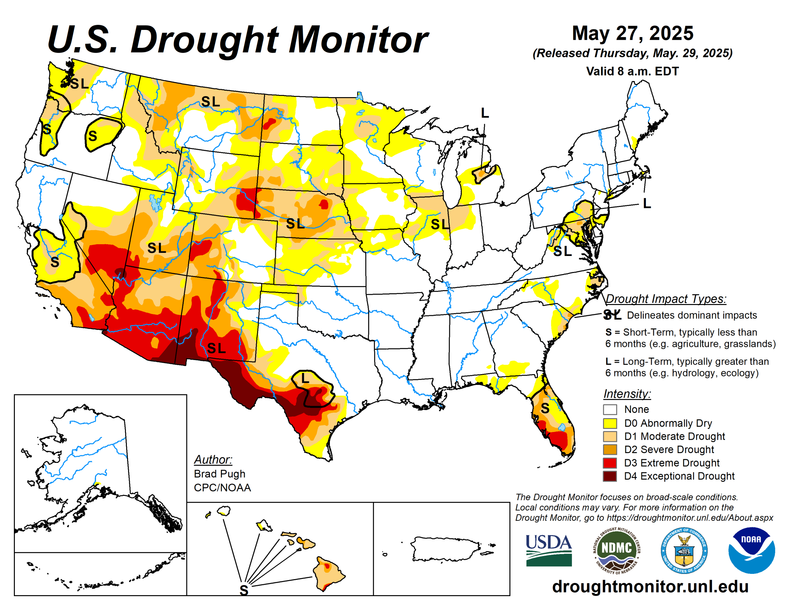
Widespread precipitation (2 inches or more) supported improvements to the drought map in the central and southern Great Plains.
During recent weeks, drought developed across portions of southwestern Iowa, northern Illinois, and northwestern Indiana. Short-term drought intensified for northwestern Colorado during mid to late May.
From May 20-26, above-normal temperatures were limited to the southern tier of the contiguous United States seven-day temperatures averaged 4 to 10 degrees Fahrenheit below normal across the Corn Belt, and northern to central Great Plains.
The U.S. Drought Monitor is jointly produced by the National Drought Mitigation Center at the University of Nebraska-Lincoln, the U.S. Department of Agriculture and the National Oceanic Atmospheric Administration. (Map courtesy of NDMC.)
South
Heavy rainfall (2 inches or more) prompted a 1-category improvement to ongoing drought areas of south-central and southeastern Texas.
Despite this recent heavy rainfall, levels in the long-term monitoring wells of Bexar and Medina Counties remain at all-time lows. In addition, many of the 28-day average USGS streamflows are below the 5th percentile, supporting the D3-D4 depiction.
Since the SPIs dating back six months are neutral and considering the major impact is hydrological, the drought impact was changed to long-term only. With drought improvement for northwestern Oklahoma, nearly all of Oklahoma and northern to eastern Texas are drought-free. The Lower Mississippi Valley and Tennessee Valley are also drought-free with surplus 30 to 90-day precipitation.
Midwest
On May 20 and 21, a low pressure system resulted in a widespread swath of 1 to 2 inches of precipitation from Minnesota southeastward to Wisconsin, leading to 1-category improvements.
However, western to southern Iowa, northern Illinois, northern Indiana, and adjacent southwestern Michigan received lower precipitation amounts this past week. Increasing 30-day precipitation deficits and declining soil moisture led to an expansion of moderate drought (D1) and abnormal dryness (D0) for these areas. Northern Missouri has also been on the drier side during the past 30 days which prompted an increase in D0 coverage.
High Plains
From May 24-26, widespread precipitation (1 to 3 inches, locally more) resulted in a 1-category improvement to portions of southwestern South Dakota, Nebraska, Kansas, and northeastern Colorado. Much cooler temperatures accompanied this widespread precipitation which contributed to topsoil moisture recharge.
Based on multiple indicators such as the SPI at various time scales and soil moisture, severe (D2) to extreme (D3) drought was reduced in coverage across central to western Nebraska along with adjacent areas of southwestern South Dakota.
Although precipitation was lighter across southeastern Colorado, SPIs at multiple time scales, soil moisture, and VegDri no longer support any D1. Southern Nebraska and northern Kansas missed out on this past week’s precipitation and a couple of small 1-category degradations were made. A 1-category degradation was also warranted for western Colorado based on 90 to 180-day SPI.
West
Although precipitation was light this past week, SPIs dating back 120 days along with more favorable soil moisture indicators led to improvements across southwestern and eastern Montana.
Conversely, in northwest Montana, D1 was degraded to D2 based on 120-day SPI and declining soil moisture. To the east of the Sierra Nevada Mountains, abnormal dryness (D0) was expanded to the south of Lake Tahoe due to drier-than-normal conditions since April.
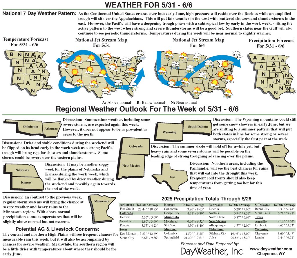
Looking ahead
A low-pressure system and trailing front are forecast to maintain the wet pattern along the East Coast with the Weather Prediction Center depicting 1 to 2 inches of precipitation from the Mid-Atlantic north to England through June 2. Much-needed precipitation (locally more than 1 inch) is expected for the Florida Peninsula.
From May 29 to June 2, mostly dry weather is forecast across the Midwest. By June 2, a low-pressure system is forecast to develop and bring another round of precipitation to the northern and central High Plains. Much above-normal temperatures and potential record heat are predicted to affect California and the Great Basin as of May 31.
The Climate Prediction Center’s six- to 10-day outlook (valid June 3 to 7) favors above-normal precipitation for the Florida Peninsula, Middle to Upper Mississippi Valley, and Great Plains. The precipitation outlook leans toward above-normal precipitation for much of the West.
Above-normal temperatures are favored from the Mississippi Valley to the East Coast, while below-normal temperatures are more likely throughout the West.
Brad Pugh is with the National Oceanic Atmospheric Administration and Climate Prediction Center.
Related Articles


