Texas dealing with damage as a result of recent storms
Gov. Greg Abbott has directed the Texas Division of Emergency Management to activate additional state emergency response resources ahead of increased threats of severe weather and flooding expected to impact the state over the next several days.
An Abilene, Texas, news station was knocked off the air as the result of rain, hail and lightning, according to media outlets.
“Texas stands ready to deploy all necessary resources to support Texans as severe weather moves across our state that has potential to bring flash flooding and heavy rain,” Abbott said. “Texans are urged to remain weather-aware, regularly check road conditions, and heed the guidance of state and local officials to ensure the safety of themselves and their loved ones. Regularly monitor roadways before traveling and check TexasFlood.org for flood information. Remember: Turn Around, Don’t Drown.”
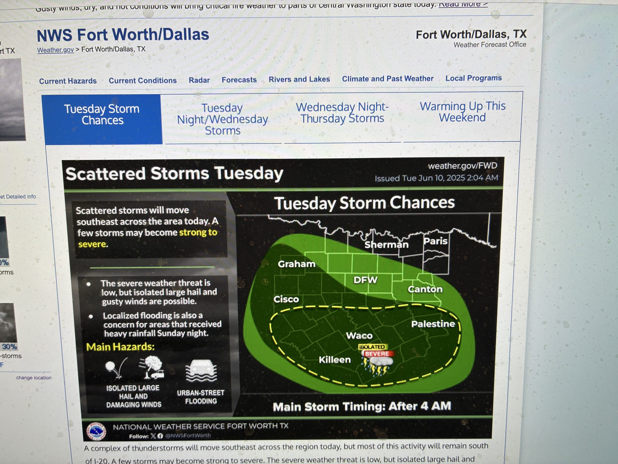
According to the National Weather Service, severe weather is forecasted across large portions of the Panhandle, north, west, and east Texas that began June 8 and lasting through the week. Expected impacts include damaging wind, very large hail, possible tornadoes, excessive rainfall, and flash flooding. Wind gusts in excess of 80 to 100 miles per hour are possible later today. The rain and flood threat intensifies mid-week across north, central, east, and south Texas. Texans are urged to monitor local forecast information from trusted weather sources.
West Texas has been dealing with the impact of damaging wind and heavy rain June 2, according to the National Weather Service in Lubbock. The most widespread impact from the activity was the strong to severe wind gusts that it generated. Several locations, including in and around Tulia, Tahoka and north of Lubbock incurred damage from the intense winds. A peak wind gust of 67 mph was recorded by the West Texas Mesonet site north of Dimmitt, while stations near Tulia, Happy, Abernathy and Smyer measured gusts near or slightly about 60 mph.
Large hail and strong winds were also reported May 29, according to the National Weather Service.
The supercell storms quickly became proficient hail producers. A hail stone as large as 3.50 inches in diameter (close to softball size) was measured 6 miles north of Brownfield.
Many other reports of ping pong to golf ball sized hail were received along the track of the thunderstorm as it moved southeast across Brownfield, Union and Punkin Center. A report of 3 inch diameter hail was received as far southeast as near Big Spring.
The activation of additional state emergency response resources comes after the Governor directed TDEM to deploy resources in anticipation of severe weather threats last week.
Texans are encouraged to proactively prepare for severe weather by packing an emergency supply kit, making an emergency plan, and following guidance from local officials. Texans can find flood and severe weather safety information at TexasReady.gov, check road conditions at DriveTexas.org, and access all-hazards preparedness tips at tdem.texas.gov/prepare.
Dave Bergmeier can be reached at 620-227-1822 or [email protected].
Related Articles